Itinerary
Day 1 :
Paro Airport - Thimphu
<p>(Distance: 65 kms. / Driving Time: 2 hrs. / Altitude of Thimphu: 2350 mts.)On arrival at Paro Airport and after completing your Visa / Permit formalities you will be received by our Bhutan representative who will assist you in boarding your vehicle for transfer to Thimphu (2320Mts / 7656Fts, 65 Kms / 01½ to 02 Hrs), Thimphu is the capital town of Bhutan and the centre of government, religion and commerce, Thimphu is a unique city with unusual mixture of modern development alongside ancient traditions. Although not what one expects from a capital city, Thimphu is still a fitting and lively place. Home to civil servants, expatriates and monk body, Thimphu maintains a strong national character in its architectural style. On arrival in Thimphu, Check in to the hotel. Evening free at leisure. Overnight at Hotel.</p>
Day 2 :
Thimphu Sightseeing
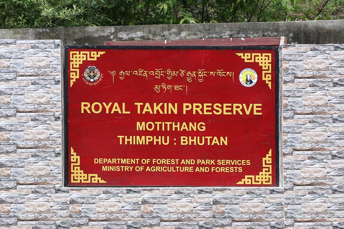
<p>After breakfasts go for Thimphu sightseeing covering Memorial Chorten, TashichhoDzong, Buddha Point (KuenselPhodong),Changangkha Lhakhang (Monastery), Motithang Takin Preservation Centre (presently closed for tourist),DrupthobGoemba / Zilukha Nunnery, National Library (Closed on Saturday , Sunday & National Holiday),Institute for ZorigChusum (Traditional Art & Craft School)(Closed on Saturday , Sunday, National Holiday & During Summer & Winter Vacations), Textiles Museum (Handicrafts Shops) (Closed on Saturday,Sunday& National Holiday), Zangthopelri Lhakhang (Monastery). Overnight at Hotel.</p>
Day 3 :
Thimphu - Punakha/Wangdue Sightseeing
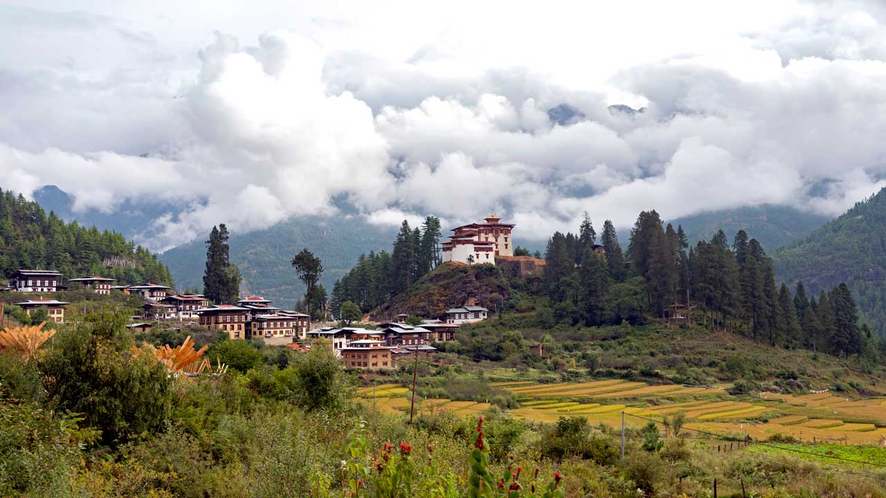
<p>(Distance: 77 kms. / Driving Time: 3 hrs. / Altitude of Punakha: 1310 mts.) After breakfast drive to Punakha (1200Mts / 3936Fts, 77 Kms / 03 to 3½ Hrs) /Wangdi (Wangdiphodrang) (1350Mts / 4430Fts, 70 Kms / 03 to 3½ Hrs). Punakha / Wangdi is the last town on the highway before entering Central Bhutan. The drive is over Dochu La pass(3080Mts / 10102Fts) which is very scenic with fascinating view of mountains of Bhutan. Stopping briefly here to take in the view and admire the Chorten, Mani wall, and Prayer flags which decorate the highest point on the road. If skies are clear, the following peaks can be seen from this Pass (Left to Right): Mt. Masagang (7,158Mts / 23478Fts), Mt. Tsendagang (6,960Mts / 22829Fts), Mt.Terigang (7,060Mts / 23157Fts), Mt. Jejegangphugang (7,158Mts / 23478Fts), Mt. Kangphugang (7,170Mts / 23518Fts), Mt. Zongphugang (7,060Mts / 23157Fts), a table mountain that dominates the isolated region of Lunana - Finally Mt.Gangkar Puensum (7,497Mts / 24590Fts), the highest peak in Bhutan. Visit Punakha Dzong (Which is closed in Winter months when the monk body are in Punakha. All visits to Punakha Dzong& Monastery are limited till Courtyard only. All tourists visiting Dzongs and temples must be dressed appropriately. No half pant, sleeve less shirts, floaters, etc are allowed) - Built Strategically at the junction of Pho Chhu (Father) and Mo Chhu (Mother) rivers in 1637, by ShabdrungNgawangNamgyal to serve as the religious and administrative centre of the region, Punakha Dzong has played an important role in Bhutan's history. Damaged by Four catastrophic fires and an earthquake, the Dzong has been fully restored by the present King. The Dzong is open for visitors during Punakha Festival and in summer months when the monk body moves to Thimphu. Visit Punakha Dzong, If time permit visit the Suspension Bridge and then proceed to Chimi Lhakhang (Monastery),Overnight at the Hotel in Wangdi.</p>
Day 4 :
Punakha/Wangdue - Excursion to Gangtey (Phobjikha) - Punakha/Wangdue
<p>(Distance: 78 kms. One way / Driving Time: 3 hrs.)Today the day start early for full day excursion to Gangtey&Phobjikha Valley (3000Mts / 9845fts , 85Kms / 3 to 3½ Hrs One way ) The valley of Gangtey is one of the most beautiful spots in Bhutan. The surprise of finding such a wide, flat valley without any trees after the hard climb through dense forests is augmented by an impression of vast space, and extremely rare experience in Bhutan where most of the valley’s are tightly enclosed. A few kilometers beyond the Gangtey Monastery, on the valley floor lie’s the village of Phobjikha. This place is the winter home of black necked cranes that migrate from the arid plains in the north to pass winter in milder and lower climate. Phobjikha, at an altitude of 2900 m, falls under the district of Wangdiphodrang and lies on the periphery of the Black Mountain National Park. The valley boasts two beautiful meandering rivers, NakayChhu (ChhuNaap-black water) and Gay Chhu (Chhu Karp-white water). According to a local legend, the two rivers actually represent a snake and a boar. The two animals once raced each other with an agreement that if the snake (NakayChhu) won, Phobjikha valley would be able to grow rice, but if the boar won, then rice could never be cultivated in the area. The snake lost since it had to meander all the way during its journey. Rice cannot be cultivated in the valley even today.n Later visit Black Necked Crane Information Centre , GangteyGoempa (Monastery),Back to the hotel. Overnight at Hotel. </p>
Day 5 :
Punakha/Wangdue - Paro Sightseeing
<p>(Distance: 140 kms. / Driving Time: 5 hrs. / Altitude of Paro: 2280 mts.)After breakfast transfer to Paro(2134Mts /7000Fts, 135 Kms / 05 Hrs). Enroute Stop at Lamperi to visit Royal Botanical Garden. On arrival Paro, check in to the hotel. Afternoon free at leisure.Overnight at Hotel.</p>
Day 6 :
Paro Sightseeing
<p>After breakfast go for Paro Sightseeing DrukgyelDzong(Presently closed for tourist),Ta Dzong (National Museum-Closed on Saturday, Sunday & National Holiday), RinpungDzong, Kyichu Lhakhang (Monastery),Back to the hotel. Overnight at Hotel.</p><p>OR PARO - FULL DAY HIKE TO TAKTSANG LHAKHANG (TIGER`S NEST)( Additional cost)</p><p>Start the day early for a day hike to Taktsang Lhakhang (Tiger's Nest Monastery) (Tuesday Closed) -The hike which is all the way uphill takes about 2 /3 hours through pine forests. The monastery clings to a huge granite cliff 800 meters from the Paro valley. It is one of the most famous of Bhutan's monasteries, perched on the side of a cliff 900m above the Paro valley floor. It is said that Guru Rinpoche arrived here on the back of a tigress and meditated at this monastery and hence it is called "Tiger's Nest". This site has been recognized as a most sacred place and visited by ShabdrungNgawangNamgyal in 1646 and now visited by all Bhutanese at least once in their lifetime. On 19 April, 1998, a fire severely damaged the main structure of building but now this Bhutanese jewel has been restored to its original splendour. Afternoon at leisure for go for shopping in the market. Overnight at Hotel.</p>
Day 7 :
Paro - Excursion to Haa Valley - Paro
<p>(Distance: 35 kms. One way / Driving Time: 2 hrs. / Altitude of Chele-La-Pass: 3810 mts.)Start the day early for a full day excursion to Haa via Chele-la pass (3800Mts / 12465Fts, 65 Kms / 02 to 03Hrs – One way) with packed or early breakfast. Drive for 4 Kms away at Bondey village the road to Haa diverts towards the right hand side and ascends towards the Chele-la pass starts. After driving through Blue Pine & Rhododendron Forest for 45 km, reach Chele-la pass (3988Mts / 13081Fts). From this point one can have a superb view of Mt. Jhomolhari (7134Mts / 23400Fts) & Mt. Jichu Drake (6989Mts / 22924Fts). This is a very good place to walk around for few minutes enjoying the view. Drive on to Haa, descending all the way for another 22 km (under an hour’s drive), finally reaching Haa. Visit HaaDzong,Lhakhang Karpo, Lhakhang Nagpo,WangchuloDzong. Evening you drive back to Paro. Overnight at the hotel.</p>
Day 8 :
Paro Airport
<p>After breakfast transfer to Paro Airport for taking onwards connection with the beautiful memories of Bhutan.</p>